[]
Ihre AuswahlIhre aktuelle Auswahl
asset(s) Assets
Ihr Preis 0

Ihre Auswahl

Auswahl aufheben
Asset zum Warenkorb hinzugefügt
{"event":"pageview","page_type1":"undetected","page_type2":"_assets_search_override","language":"de","user_logged":"false","user_type":"ecommerce","nl_subscriber":"false"}
{"event":"ecommerce_event","event_name":"view_item","event_category":"browse_catalog","ecommerce":{"items":[{"item_id":"RGS242201","item_category":"photo","item_category2":"out_of_copyright","item_category3":"standard","item_category4":"maull_fl_1850s_60s_polyblank_fl_1850s","item_category5":"not_balown","item_list_name":"search_results","item_name":"portrait_of_sir_george_everest_1790_1866_sepia_photo","item_variant":"undefined"},{"item_id":"UIG539104","item_category2":"out_of_copyright","item_category3":"standard","item_category5":"not_balown","item_list_name":"search_results","item_name":"death_valley_first_full_scene_from_thematic_mapper_on_land_sat_4_vegetation_sparse_terrain_dominated","item_variant":"undefined"},{"item_id":"XOS3742366","item_category":"photo","item_category2":"no_copyright","item_category3":"standard","item_category5":"balown","item_list_name":"search_results","item_name":"cyclones_encircle_jupiter_s_north_pole_photo","item_variant":"undefined"},{"item_id":"TPG165976","item_category":"photo","item_category2":"out_of_copyright","item_category3":"standard","item_category4":"american_school_19th_century","item_category5":"not_balown","item_list_name":"search_results","item_name":"group_portrait_of_union_mappers_at_antietam_maryland_1862_b_w_photo","item_variant":"undefined"},{"item_id":"PIX4675677","item_category":"photo","item_category2":"no_copyright","item_category3":"standard","item_category5":"not_balown","item_list_name":"search_results","item_name":"tahiti_view_from_space_tahiti_seen_from_space_tahiti_the_largest_island_in_french_polynesia_seen_by_","item_variant":"undefined"},{"item_id":"EVB2931617","item_category":"photo","item_category2":"undetermined_copyright","item_category3":"standard","item_category5":"not_balown","item_list_name":"search_results","item_name":"aftermath_of_the_world_trade_center_attack_2001_photo","item_variant":"undefined"},{"item_id":"PIX4672475","item_category":"photo","item_category2":"no_copyright","item_category3":"standard","item_category5":"not_balown","item_list_name":"search_results","item_name":"bering_glacier_alaska_bering_glacier_in_alaska_the_bering_glacier_is_the_largest_glacier_in_north_am","item_variant":"undefined"},{"item_id":"PIX4673124","item_category":"photo","item_category2":"no_copyright","item_category3":"standard","item_category5":"not_balown","item_list_name":"search_results","item_name":"mississippi_delta_louisiana_seen_by_satellite_mississippi_river_delta_louisiana_mississpi_delta_loui","item_variant":"undefined"},{"item_id":"PIX4658462","item_category":"photo","item_category2":"no_copyright","item_category3":"standard","item_category5":"not_balown","item_list_name":"search_results","item_name":"satellite_photo_of_the_rub_al_khali_desert_rub_al_khali_desert_seen_from_space_rub_al_khali_the_empt","item_variant":"undefined"},{"item_id":"PIX4675619","item_category":"photo","item_category2":"no_copyright","item_category3":"standard","item_category5":"not_balown","item_list_name":"search_results","item_name":"grande_terre_new_caledonia_view_from_space_grande_terre_new_caledonia_seen_from_space_in_july_2008_u","item_variant":"undefined"},{"item_id":"UIS5104174","item_category":"photo","item_category2":"no_copyright","item_category3":"standard","item_category5":"not_balown","item_list_name":"search_results","item_name":"chimborazo_and_tungurahua_ecuador_september_16_2001","item_variant":"undefined"},{"item_id":"PIX4672471","item_category":"photo","item_category2":"no_copyright","item_category3":"standard","item_category5":"not_balown","item_list_name":"search_results","item_name":"glacier_bay_alaska_glacier_bay_in_alaska_glacier_bay_from_perspective_this_image_is_the_result_of_jo","item_variant":"undefined"},{"item_id":"PIX5894554","item_category":"photo","item_category2":"no_copyright","item_category3":"standard","item_category5":"not_balown","item_list_name":"search_results","item_name":"sivash_lagoons_crimea","item_variant":"undefined"},{"item_id":"UIS5072449","item_category":"photo","item_category2":"no_copyright","item_category3":"standard","item_category5":"not_balown","item_list_name":"search_results","item_name":"satellites_earth_observation_usa_landsat_d_satellite_before_launch_1982","item_variant":"undefined"},{"item_id":"PIX4660095","item_category":"photo","item_category2":"no_copyright","item_category3":"standard","item_category5":"not_balown","item_list_name":"search_results","item_name":"jeju_volcanic_island_south_korea_jeju_volcanic_island_south_korea_jeju_volcanic_island_seen_by_lands","item_variant":"undefined"},{"item_id":"UIS5072434","item_category":"photo","item_category2":"no_copyright","item_category3":"standard","item_category5":"not_balown","item_list_name":"search_results","item_name":"satellites_earth_observation_usa_landsat_d_satellite_before_launch_1982","item_variant":"undefined"}]}}
{"event":"custom_event","event_name":"view_search_result","event_category":"browse_catalog","keyword":"mapper","search_type":"standard","search_bridgeman_artists":"false","search_mode":"automatic","search_zero_result":"false","search_results":16,"search_results_page_number":1}

'Mapper' Bilder und Clips Suchergebnisse page 1 of 1

Hauptfilter
Option "Kunstdruck kaufen" verfügbar
Royalty-free Optionen
Ecommerce option
Medium
Orientation
Farbbilder
Kategorie
Rechte
Mehr Filter
Bridgeman Artists
Bridgeman Fotografen
Jahrhundert
Footage-Filter
Video Original Format
Video Resolution
Video Category
Filter group
Filter colors
Sortieren nach:
pro Seite
Filter group
Kategorie
Medium
No copyright
Filter colors

Anzeigeoptionen

View
Image Size

Bilder zu 'Mapper' gefunden, 16

Cyclones encircle Jupiter's North Pole (photo)
Nutzungsbeschränkungen von unseren Content-Partnern
  • Editorial use only
Tahiti view from space - Tahiti seen from space - Tahiti, the largest island in French Polynesia, seen by the Landsat satellite - 7 on 11 July 2001. The Enhanced Thematic Mapper Plus on the Landsat 7 satellite captured this natural - color image of Tahiti on July 11, 2001. This island is part of a volcanic chain formed by the northwestward movement of the Pacific Plate over a fixed hotspot. Tahiti consists of two old volcanoes - - Tahiti - Nui in the northwest and Tahiti - Iti in the southeast - - linked by an isthmus
Aftermath of the World Trade Center Attack, 2001 (photo)
Zusätzliche Genehmigungen
  • Permission required for non-editorial use (inc book and magazine covers). Please contact us
Nutzungsbeschränkungen von unseren Content-Partnern
  • Not available to clients invoiced in Japan
Bering Glacier, Alaska - Bering Glacier in Alaska - The Bering Glacier is the largest glacier in North America. Since 1900, the glacier front has receded 12 km. Image obtained by Landsat-7 satellite on 29 September 2002. Bering Glacier currently terminates in Vitus Lake south of Alaska's Wrangell - St. Elias National Park, about 10 km from the Gulf of Alaska. Combined with the Bagley Icefield, where the snow that feeds the glacier accumulates, the Bering is the largest glacier in North America. Warmer temperatures and changes in precipitation over the past century have thinned the Bering Glacier by several hundred meters. Since 1900 the terminus has retreated as much as 12 km. Most of the glaciers along the Alaskan coast are retreating along with the Bering Glacier. This true - color image of the Bering Glacier terminus was acquired on September 29, 2002, by the Enhanced Thematic Mapper plus (ETM +) instrument aboard the USGS/NASA Landsat - 7 satellite
Mississippi Delta, Louisiana, seen by satellite - Mississippi River Delta. Louisiana - Mississpi Delta, Louisiana, USA, seen by Landsat-7 satellite, November 27, 1999. The Mississippi River drains the heart of the North American continent, carrying vast quantities of sediment and depositing it along the shore of Louisiana and into the Gulf of Mexico. The sediment is composed of topsoil, sand, dead and decaying plants, and anything else washed away by a strong rainstorm far upstream. Many of these effluents are nutrients that act as fertilizer for the microscopic plants (phytoplankton) living near the surface of the Gulf waters. Each summer the phytoplankton population explodes. As the phytoplankton age, die, and decompose, bacteria absorb oxygen dissolved in the water, creating a dead zone”” along the shore at the ocean bottom. The oxygen - poor water is deadly to animals, from the microscopic zooplankton that graze on phytoplankton to crustaceans, molluscs, and fish. Once infrequent, the Gulf of Mexico dead zone is now an annual event, triggered by phosphorus and nitrogen in fertilizers used on farms throughout the central United States and as far away as Saskatchewan, Canada. In the fall, strong winds from seasonal storms stir the water, mixing the oxygen - poor deep water with oxygen - rich surface water, bringing a reprieve until the next spring. The true - color image above was acquired on November 27, 1999, by the Enhanced Thematic Mapper plus (ETM +) aboard Nasa's Landsat 7 satellite.
Satellite photo of the Rub al Khali desert - Rub 'al Khali desert seen from space - Rub al-Khali (the Empty Quarter), is one of the largest deserts and the largest uninterrupted expanse of sand in the world. It covers nearly 600,000 square kilometres in the Arabian Peninsula, located mostly in Saudi Arabia and in the territories of Yemen, Oman and the United Arab Emirates. The image obtained by the Landsat-7 satellite on 26 August 2001 shows the sand dune fields separated by flat and saline stretches, sebkha (or sabkha). The Arabian Peninsula's Empty Quarter, known as Rub 'al Khali, is the world's largest sand sea, holding about half as much sand as the Sahara Desert. The Empty Quarter covers 583,000 square kilometers (225,000 square miles), and stretches over parts of Saudi Arabia, Yemen, Oman, and the United Arab Emirates. The Enhanced Thematic Mapper on Nasa's Landsat 7 satellite captured this image of the Empty Quarter on August 26, 2001. The area shown resides in southeastern Saudi Arabia, midway between the United Arab Emirates to the north and Oman in the south. Parallel rows of salmon - pink and white alternate to create a rippling pattern. White salt flats, known as sebkhas or sabkhas, separate the dunes. These salt - encrusted plains vary in hardness, in some places creating a surface strong enough to drive a vehicle over, in other places disappearing into sand. The sand dunes soar above the salt plains between them
Grande Terre, New Caledonia, view from space - Grande Terre, New Caledonia, seen from space - In July 2008, UNESCO added 27 places to the World Heritage List. The lagoons of New Caledonia are one of them. Satellite image centered on the island of Balabio and Grande-Terre obtained by the Landsat-7 satellite on 10 May 2001. In July 2008, UNESCO added 27 new areas to its list of World Heritage sites. One of those areas included the lagoons of New Caledonia. Some 1,200 kilometers (750 miles) east of Australia, this English - governed archipelago contains the world's third - largest coral reef structure. The coral reefs enclose the waters near the islands in shallow lagoons of impressive biodiversity. On May 10, 2001, the Enhanced Thematic Mapper Plus on Nasa's Landsat 7 satellite captured this image of Ile Balabio, off the northern tip of Grande Terra, New Caledonia's main island. In this natural - color image, the islands appear in shades of green and brown - - mixtures of vegetation and bare ground. The surrounding waters range in color from pale aquamarine to deep blue, and the color differences result from varying depths. Over coral reef ridges and sand bars, the water is shallowest and palest in color. Darker shades of blue characterize deeper waters. Reef - enclosed, shallow waters surround Ile Balabio, and a larger, semi-enclosed lagoon appears immediately east of that island. Immediately north of Grande Terra, unenclosed, deeper waters predominate
Chimborazo and Tungurahua, Ecuador, September 16 2001
Nutzungsbeschränkungen von unseren Content-Partnern
  • Not available to clients invoiced in the UK
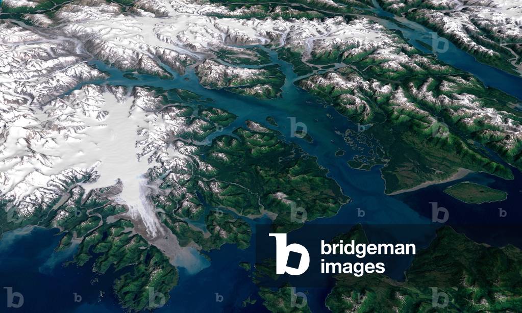
Glacier Bay, Alaska - Glacier Bay in Alaska - Glacier Bay from perspective. This image is the result of joint observations made by the Landsat-7 satellite in visible and infrared, combined with elevation radar data obtained by the Shuttle Radar Topography Mission (SRTM) in February 2000. At the bottom left of the picture, the Brady Glacier. Glacier Bay National Park and Preserve lies on the Pacific Coast of Alaska south of the St. Elias mountain range. The bay was set aside as a National Monument in 1925 and became its current National Park and Preserve in 1980, when approximately 85 percent of the park was designated a Wilderness Area. It has since been recognized as a UN Biosphere Reserve, in 1986, and a World Heritage Site, in 1992. The water in the foreground in the southwest (bottom left) corner of the image is the Gulf of Alaska, with Icy Strait running roughly west to east (horizontally) in from Cape Spencer where the strait meets the Pacific. The foreground glacier is the Brady Glacier. The light gray feature at the foot of the glacier is fine silt dropped by the glacier as it melts. The glacier's meltwater washes the silt into the Strait, coloring the shallow waters light blue as the silt mixes. The long finger of water dominating the entire scene is Glacier Bay itself. The Grand Pacific Glacier now terminates well above Tar Inlet, the finger of water stretching furthermost north (up) at the top of Glacier Bay. The first major inlet on the east (right) coming up from the mouth of Glacier Bay is Muir Inlet. The glaciers feeding into the bay terminated here around 1860. The body of water paralleling the Bay on the eastern edge is Lynn Canal, a body of water also draining into Icy Strait beyond the eastern boundary of the park. This image is a visualization created by merging imagery from the Landsat 7 satellite's Enhanced Thematic Mapper Plus (ETM +) instrument with elevation data from the USGS National Elevation Dataset (NED). This true - color imag
Sivash Lagoons - Crimea
Satellites, Earth Observation, USA Landsat D satellite before launch, 1982
Nutzungsbeschränkungen von unseren Content-Partnern
  • Not available to clients invoiced in the UK
Jeju volcanic island, South Korea - Jeju volcanic island, South Korea - Jeju volcanic island seen by Landsat satellite - 7 on April 6, 2000. This island, classified as a World Heritage Site, is home to the highest peak of South Korea, Mount Halla (1950 m), a volcano shield whose last eruption dates back to 1007. Cheju Island, is an oval - shaped volcanic landmass covering 1,845 square kilometers (712 square miles) off the southern tip of the Korean Peninsula. Geologists estimate the island's age at 2 million years, and archaeological finds suggest that people have lived on the island since prehistoric times. Today, Cheju is both a tourist attraction and home to an UNESCO World Heritage site. The Enhanced Thematic Mapper Plus on Nasa's Landsat - 7 satellite captured this image of Cheju Island on April 6, 2000. In this photo - like image, cloudless skies allow a clear view of the island and the swirling blue hues of the surrounding waters. Urbanized areas, such as the capital city, Cheju, appear in shades of gray - beige along the island's perimeter. Inland, a combination of natural vegetation, cultivated fields, and bare ground creates a patchwork of tan and green. The island's dominant feature is Halla Mountain, a volcano whose last recorded eruption occurred in the year 1007. Halla Mountain is a shield volcano with a low, broad profile resembling an ancient warrior shield. It is one of the world's few shield volcanoes located over a magma hotspot”” on a stationary plate of continental crust. Rising to a height of 1,950 meters (6,398 feet), Halla Mountain is the highest peak in South Korea, and the volcano's crater holds a natural lake and numerous waterfalls. Lava tubes from the volcano have formed a network of caves complete with lava walls with carbonate rock formations. The rarity of these features combined with their instructiveness about volcanic processes has earned the site its World Heritage status.
Satellites, Earth Observation, USA Landsat D satellite before launch, 1982
Nutzungsbeschränkungen von unseren Content-Partnern
  • Not available to clients invoiced in the UK